Continents Quiz
How accurate is your mental map of the world?
Most of us walk around with a map of the world in our heads, but that mental image is often surprisingly flawed. Thanks to distorted classroom maps and common geographical myths, we tend to misplace entire continents and misunderstand the scale of our planet's greatest natural features. You might think you know exactly where the equator lies or which direction the world's longest rivers flow, but the reality of Earth's geography is full of surprises. This quiz will challenge those deeply ingrained assumptions and reveal just how well you really know our globe.
Answer the questions below to see how your mental map measures up against the real world.
Question 1 of 20
Which continent has the highest number of individual sovereign states (countries)?
BACK NEXT
The psiandme World Maps in Your Head: Continents quiz was created by psiandme.
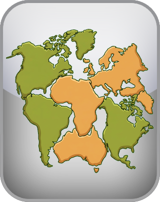
When we picture the world, many of us rely on the classic Mercator projection map that hung in our elementary school classrooms. While excellent for nautical navigation, this map drastically distorts the size of landmasses near the poles, making places like Greenland and Europe appear massive while shrinking equatorial regions. As a result, our mental maps often vastly underestimate the true size of Africa, which is actually the second-largest continent and about fourteen times larger than Greenland. This visual bias shifts our perceived center of the world, making us forget that Africa is the only continent crossed by both the Equator and the Prime Meridian.
Beyond just size, our mental alignment of the continents is frequently skewed. For instance, North and South America are often imagined as being stacked neatly on top of one another in a straight north-to-south line. In reality, the entire continent of South America lies east of Florida, and its eastern bulge reaches far across the Atlantic, making it geographically much closer to Africa than most people realize. Furthermore, Africa is unique in its global positioning, stretching into the northern, southern, eastern, and western hemispheres simultaneously, a fact that defies our tendency to categorize regions into simple hemispheric boxes.
Our understanding of Earth's extreme environments, particularly deserts, is another area where mental maps often lead us astray. Popular culture has trained us to picture deserts exclusively as scorching, sandy wastelands like the Sahara, which is indeed the largest hot desert on the planet. However, in geography, a desert is defined strictly by its lack of precipitation rather than its temperature. This means that the largest desert on Earth is actually the Antarctic Desert, a vast, freezing expanse of ice. Similarly, the Gobi Desert in Asia experiences freezing winters, proving that arid landscapes are far more diverse than endless sand dunes.
Mountains shape the continents in ways that our mental maps sometimes oversimplify or ignore entirely. The Andes in South America form the longest continental mountain chain in the world, stretching along the western edge of the continent and profoundly influencing its climate and ecosystems. Meanwhile, Asia boasts the highest peaks, including Mount Everest, but it is also home to the lowest land elevation at the shores of the Dead Sea. Even continents we might imagine as relatively flat have significant ranges; Australia features the Great Dividing Range, and Antarctica hides the massive Transantarctic Mountains beneath its ice sheets.
Rivers are the lifeblood of the continents, yet they are surrounded by pervasive geographical myths. A common misconception is that all major rivers flow south, perhaps because we intuitively associate south with down on a map. In truth, rivers simply flow downhill from higher to lower elevations, regardless of compass direction, which is why the mighty Nile River famously flows north into the Mediterranean Sea. The Amazon River, which carries the greatest volume of water of any river on Earth, actually used to flow westward toward the Pacific Ocean before the uplift of the Andes mountains forced it to reverse its course and drain into the Atlantic.
The very definition of a continent is more cultural and historical than strictly geological, a fact best illustrated by Eurasia. Europe and Asia form one continuous, massive landmass, yet they are traditionally divided into two continents despite the lack of a separating ocean. This cultural division creates unique geographical quirks, such as the city of Istanbul straddling the boundary between Europe and Asia. Understanding these nuances helps us realize that the maps in our heads are not just physical representations of the Earth, but are also shaped by human history, exploration, and storytelling.
The slow but constant movement of tectonic plates means that our current map of the world is just a temporary snapshot in geological time. Continents drift at roughly the same speed that human fingernails grow, constantly reshaping the globe. For example, the East African Rift is slowly splitting Africa into two separate landmasses, a process that will eventually create an entirely new ocean basin millions of years from now. Learning about these dynamic processes reminds us that the Earth is a constantly evolving puzzle, making the study of its geography an endlessly fascinating pursuit.
For more information about our online tests and quizzes, consult our Terms of Service.
Why Use This Quiz?
1. Uncover Geographical Blind Spots. Most people are highly confident in their basic knowledge of world geography, yet they harbor fundamental misunderstandings about the size, location, and features of the continents. This quiz provides a fascinating reality check, highlighting the differences between the maps we hold in our minds and the actual physical globe. You will learn surprising facts about the true scale of Africa, the definition of deserts, and the directional flow of famous rivers. It is an engaging way to correct lifelong misconceptions and gain a more accurate perspective of the planet we call home.
2. Explore Earth's Natural Extremes. Beyond just pointing out locations on a map, this quiz delves into the fascinating extremes of our natural world. You will discover which continent boasts the longest mountain range, where the driest and windiest places are truly located, and how geological forces have shaped massive river systems over millions of years. By challenging your knowledge of these incredible natural phenomena, the quiz offers a deeper appreciation for the diverse and dynamic environments that make up Earth's continents.